· Museum Admission: Free (Public Service)
· Opening Hours: 08:00 AM - 06:00 PM
· Location: Changping Valley Visitor Center
24 Hours Hotline: +8613735411378
Email:[email protected]
24 Hours Hotline: +8613735411378
Email:[email protected]


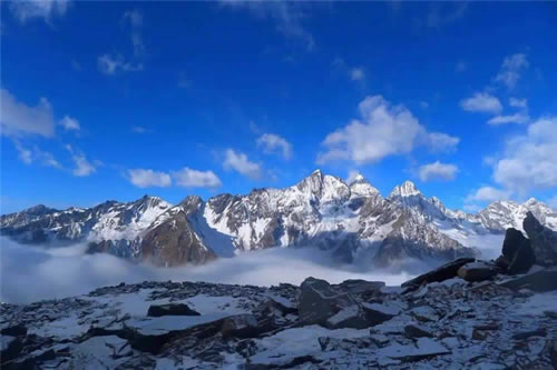
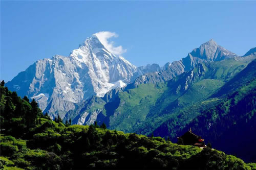
Tucked away in the majestic Qionglai Mountains of Sichuan, Siguniang National Park is a true gem for those seeking adventure, natural beauty, and a glimpse into Tibetan culture. The park is dominated by the awe-inspiring peaks of Mount Siguniang, often called the "Queen of Sichuan's Mountains," offering a stunning backdrop of snow-capped summits and deep valleys. Whether you’re trekking through lush forests, discovering high-altitude lakes, or immersing yourself in the rich traditions of local Tibetan communities, Siguniang is a place that captivates the heart and soul. With its diverse landscapes, rare wildlife, and spiritual ambiance, the park promises an unforgettable journey for explorers and culture seekers alike. Prepare to step into a world of untouched wilderness and timeless Tibetan heritage as you explore one of China’s most beautiful and remote national parks.
Chengdu: A City of Contrasts – Unforgettable Experiences Await You!
Chengdu is a city of contrasts, where ancient history and cutting-edge modernity coexist.
Let us show you both sides of this incredible destination—from the serene paths of Qingcheng Mountain to the bustling, neon-lit streets of Jinli. Whether you're a nature lover, a foodie, or someone seeking cultural immersion, our guided tours offer an opportunity to experience Chengdu in a way that's as vibrant and diverse as the city itself.
 5 Days Tibet Culture Tour with Mount Siguniang
 2 Days Ultimate Danba Private Tour with Tibetan Culture and Scenery
Introduction
Nestled among the towering mountains on the eastern edge of the Qinghai-Tibet Plateau, Siguniang National Park shines like a bright pearl deep in the Qionglai Mountains, hailed as the "Oriental Alps." As the morning mist shrouds the valleys like a light veil, the snow-capped Yaomei Peak (6,250 meters above sea level) gradually reveals its true appearance, its slender figure piercing the sky, as if four graceful girls guarding this land — hence the name "Siguniang Mountain" (Four Girls Mountain). Here, there is no hustle and bustle of the city, only the wind, the gurgling streams, and the occasional tinkle of yak bells weaving a natural melody. Not only does it boast a three-dimensional landscape composed of snow-capped mountains, glaciers, canyons, lakes, and meadows, but it also preserves a cultural scroll written by the Tibetan people who have lived here for generations. Whether you are a hiking enthusiast seeking self-challenge, a photography lover chasing ultimate scenery, or a cultural explorer eager to immerse yourself in Tibetan customs, Siguniang National Park will present you with a soul-stirring travel experience in its purest form. Every visitor can find inner peace and freedom in the integration of nature and humanity.
Website: https://www.sgns.cn/
The Legend of Mount Siguniang
Siguniang Mountain Town, originally called Rilong, was also known as Rilong Pass. The name "Rilong" means "Four Valleys" and is derived from the four valleys surrounding the area. The name of Siguniang Mountain and Rilong Town is linked to the Jiarong Tibetan people who have lived there for generations. The Tibetans refer to Siguniang Mountain as Sgu La Rou Da, often shortened to Sgu La. "Sgu La" means "birth deity" and "Rou Da" refers to the local deity of the area. Siguniang Mountain is believed to be the dwelling place of the deity of birth and the local guardian spirit. The earliest references to Sgu La can be found in the 8th-century text The Lesser Praise of Sgu La by Guru Padmasambhava.
In Tibetan culture, many snow-capped mountains are revered as sacred. To the west of Xiaojin County lies the famous sacred mountain Jiar Mo Mo Er Duo, which has been worshipped for centuries. It is as respected as the Himalayas and the Gangdise Mountains in Tibetan regions. The mountain deity of Jiar Mo Mo Er Duo is said to take on the form of a powerful warrior god. It is believed that Siguniang Mountain is one of the three "birth deities" among the 62 great mountains surrounding Jiar Mo Mo Er Duo. The three deities are Wo Ri Sgu La, Zhe Duo Sgu La, and Han Niu Sgu La. Wo Ri Sgu La is depicted riding a white steed and guarding Rilong Pass.
Each year, on the 4th day of the 5th lunar month, the Sgu La Smoke Offering and Horse Sacrifice Festival is held. On this day, local men and women wear festive attire and ascend to Siguniang Mountain for the grand sang (incense offering) and "horse sacrifice" rituals. The name "Sgu La" was later mistakenly interpreted as "Siguniang" (Four Girls), and over time, the protective deity became associated with the tale of four beautiful sisters, leading to the creation of the popular legend of the "Four Girls Mountain." The original name of Sgu La is rarely known, but "Siguniang Mountain" has become widely famous.
Park Overview
1. Location & Transportation Hub
Siguniang National Park is located in Rilong Town, Xiaojin County, Aba Tibetan and Qiang Autonomous Prefecture, Sichuan Province, between 102°42'-102°58' E longitude and 30°54'-31°16' N latitude. Approximately 200 kilometers from Chengdu, the capital of Sichuan Province, it takes 4-5 hours by car, making it the closest high-altitude snow-capped mountain scenic area to a major Chinese city. Adjacent to Wolong Giant Panda Nature Reserve to the north, Baoxing Fengtongzhai Nature Reserve to the south, and Danba County to the west, the park is at the core of the western Sichuan tourism loop, serving as an important travel hub connecting Chengdu, Danba, Maerkang, and other regions.
2. Core Landforms & Scenic Composition
Covering an area of 480 square kilometers, the park centers on four connected peaks of Mount Siguniang — Yaomei Peak (6,250 meters, the highest peak of the Qionglai Mountains, known as the "Queen of Shu Mountains"), Third Girl Peak (5,355 meters), Second Girl Peak (5,276 meters), and First Girl Peak (5,025 meters). Arranged in a straight line, the four peaks are covered in perpetual snow, shining brightly under the sun. The park features diverse landforms, including alpine canyons, glacial landforms, alpine meadows, primeval forests, and alpine lakes, forming a unique climatic landscape where "one mountain has four seasons, and ten miles have different weather." The core scenic area is divided into three parts: Shuangqiao Valley (34 kilometers long, with the densest attractions), Changping Valley (29 kilometers long, a paradise for hiking and horse riding), and Haizi Valley (30 kilometers long, with original alpine lake groups). In addition, there are viewing platforms such as Guozhuangping and Chaoshanping.
3. Ecological Resources & Biodiversity
As a national nature reserve and a World Natural Heritage candidate site, Siguniang Mountain boasts a well-preserved ecosystem. The park is home to over 2,000 species of higher plants, including national protected species such as alpine rhododendrons, redwoods, Sichuan redwoods, and cercidiphyllum japonicum. It also houses 267 species of vertebrates, including more than 10 national first-class protected animals such as giant pandas, golden monkeys, clouded leopards, and snow leopards, as well as over 30 national second-class protected animals such as Tibetan macaques, red pandas, and tufted deer. As an important part of the giant panda habitat, it is also one of the core areas of biodiversity in eastern Qinghai-Tibet Plateau, known as a "genetic bank of organisms."
4. Historical Culture & Ethnic Customs
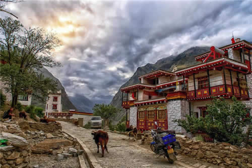
The Siguniang Mountain area is a settlement of the Jiarong Tibetans, with a long history and unique culture. As early as the Neolithic Age, there were traces of human activities here. For thousands of years, the Tibetan people have formed a lifestyle centered on Tibetan Buddhism, integrating nomadic and agricultural cultures in their coexistence with nature. Today, the park still retains intact Tibetan village architecture (such as the blockhouse residences in Changping Village and Shuangqiao Village), traditional folk customs (Guozhuang Dance, Xianzi Dance), religious beliefs (Lama Temple, prayer flags, mani piles), and unique food culture, providing tourists with an excellent opportunity to immerse themselves in Tibetan life.
5. Altitude & Climate Characteristics
The altitude of Rilong Town, the entrance to the scenic area, is about 3,100 meters. The three core scenic areas have different altitudes: Shuangqiao Valley has an average altitude of 3,800 meters (the highest attraction, Redwood Forest, is 4,000 meters above sea level), Changping Valley has an average altitude of 3,500 meters (Muluozi Camp is 3,760 meters above sea level), and Haizi Valley has an average altitude of 3,800 meters (Great Lake is 4,200 meters above sea level). The climate belongs to the subfrigid monsoon climate of the Qinghai-Tibet Plateau, with an average annual temperature of 2.8 Celsius, large temperature differences between day and night (up to 15-20 Celsius), and annual precipitation of 800-1,000 millimeters, concentrated in summer (June-August). Visitors to the park need to make adequate preparations for altitude sickness prevention and cold protection.
Core Attractions & Experiences
A. Siguniang Mountain
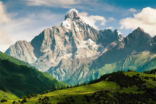
Siguniang Mountain, located on the eastern edge of the Qinghai-Tibet Plateau, marks the transition between the Sichuan Basin and the plateau. The area belongs to the Songpan-Ganzi Fold Belt and is part of the Western Sichuan Plateau's high mountain and canyon zone. The core scenic spots include three valleys—Shuangqiao, Changping, and Haizi—and four peaks: Yao Mei Peak (the main peak, 6,250 meters), San Guniang Mountain, Er Guniang Mountain, and Da Guniang Mountain. Yao Mei Peak is the highest in the Qionglai Mountain range and the second-highest in Sichuan, second only to Gongga Mountain. The area features 85 snow-capped peaks above 5,000 meters, which remain snow-covered year-round and contain modern mountain glaciers.
1.Daguniang Mountain
Below 4,000 meters, Daguniang Mountain is primarily covered by alpine meadows, with shrubs and forests at lower elevations. Yaks and horses, grazed by local herders, are commonly seen. Above 4,000 meters, the landscape becomes barren, with no vegetation, and the rocky terrain is steep and rugged, almost impossibly hard.


2. Erguniang Mountain
Erguniang Mountain features a sharp, precipitous peak with a narrow summit resembling a castle, and it is snow-capped year-round, adding to its dramatic ruggedness. On the mountain, rare animals living in the canyons of the Qinghai-Tibet Plateau can be spotted.


3. Sanguniang Mountain
Sanguniang Mountain has a sharply pointed, steep peak with a narrow summit resembling a castle, and is snow-capped year-round. Due to its extreme ruggedness, climbers who reach the summit are rare. It is classified as a beginner-level technical climb.


4. Yaomei Peak
Yaomei Peak is the second-highest peak in Sichuan. Together with Gongga Mountain, which stands at 7,508.9 meters and is known as the "King of Shu Mountains," it forms Sichuan's iconic peak duo. Yaomei Peak is often referred to as the "Queen of Shu Mountains" and the "Eastern Holy Mountain."


B. In-Depth Tour of Three Core Scenic Areas
a. Shuangqiao Valley
Shuangqiao Valley, one of the three main valleys in the Siguniang Mountain scenic area, is known for its deep development, diverse landscapes, and suitability for mass tourism. Spanning 40 kilometers and covering 216.6 square kilometers, the valley rises nearly 1,000 meters from its 2,900-meter entrance to the 3,840-meter Red Cedar Forest at its end. Named for the two wooden bridges built by locals—one from poplar and the other from red cedar—the valley is a stunning display of peaks and ravines. The scenic path leads visitors directly to the valley’s end, making exploration easy and comfortable. The valley’s steep terrain, combined with mountains, rivers, and mist, creates a fairy-tale atmosphere. Scenic spots like Ginseng Fruit Flat, Longzhu Lake, Five-Color Mountain, and Red Cedar Forest Glacier are like vibrant paintings, captivating visitors with their beauty.
* Opening Hours: Peak season: 8:00 AM - 3:00 PM
* How to Get There
· By car, or take the direct scenic bus
· By public transport from the nearby town (8 km distance)
* Recommended Way to Explore: Take the scenic sightseeing bus
* Duration of Visit: One day
* Full Route
· Check tickets at the Shuangqiao Valley Visitor Center
· Take the scenic bus directly to the final stop – Red Cedar Forest
· On the return trip, you can take the sightseeing bus to visit each attraction along the way
* Suitable For: Everyone, young and old
* Ticket Prices
· Shuangqiao Valley Entrance: 80 RMB per person
· Scenic Sightseeing Bus: 70 RMB per person
1. Sun and Moon Mirror (Riyue Baojing)
The Sun and Moon Mirror (Riyue Baojing) stands at an elevation of 5,609 meters. The peak is exceptionally unique, with its summit formed by two irregular, sloping rectangular planes. Towering and steep, the cliff walls shine brightly, slanting toward the southeast. Covered in ice and snow throughout the year, it sparkles in the sunlight, resembling a giant mirror. Suspended in the sky, these two bright mirrors appear to have a crack between them, and occasionally, one might even glimpse a silhouette resembling the face of a young woman within the mirror. The left side of the mirror resembles the character for "sun", while the right side looks like the character for "moon", which is why it is named the "Sun and Moon Mirror."


2. Five-Color Mountain (Wuse Mountain)
Located 9 kilometers within Shuangqiao Valley, Five-Color Mountain (Wuse Mountain) stands at an elevation of 5,430 meters. The peak is characterized by over 30 layers of semi-circular arcs, and from a distance, it resembles a crescent moon, making it a typical example of a folded mountain. The entire mountain is composed of rocks in various colors. These rocks contain rich minerals such as silicon, iron, zinc, and tin. Under specific sunlight conditions, the mountain displays vibrant color bands of red, yellow, green, blue, and white, with each color forming concentric rings. There are more than 30 layers from the innermost to the outermost, which is how Five-Color Mountain got its name.


3. Ginseng Fruit Flat (Rensheng Guoping)
Ginseng Fruit Flat (Rensheng Guoping) is named after a rare plant of the Rosaceae family that grows here, scientifically known as Ge Rong Wei Ling Cai. The local Jiarong Tibetans call it "Ginseng Fruit." The fruit has black skin and red flesh, with a sweet taste. It is not only edible but also used in traditional medicine, believed to have the extraordinary effects of invigorating Qi, nourishing blood, and boosting vitality.
Located at an altitude of 3,300 meters, Ginseng Fruit Flat marks the end of Shuangqiao Valley's glacial landscape. On the roadside, there are hundreds of acres of lush meadows. During the spring and summer, the meadows are blanketed with a variety of alpine flowers, resembling a massive, colorful flower basket that refreshes the senses. Cattle and sheep graze peacefully across the fields, while the area is surrounded by twisting, elegant sea buckthorn forests. The high mountains, clear waters, expansive land, and blue skies create an idyllic, paradise-like scene, as if one has stepped into a hidden utopia.


4. Longzhu Lake (Longzhu Cuo)
Longzhu Lake (Longzhu Cuo), at an altitude of 3,490 meters, is one of the main attractions in Shuangqiao Valley. The lake was formed due to the accumulation of mud and sand from mountain floods, which blocked the river and caused it to change course, submerging the sea buckthorn trees that originally grew on the land. The creek water contains rich calcified minerals, which caused large amounts of calcium to accumulate around the roots of the sea buckthorn trees. Despite dying, the trees remain standing, creating a unique and striking landscape that has become a fascinating part of the mythic world of Shuangqiao Valley.


5. Siguna Lake (Siguna Cuo)
Siguna Lake (Siguna Cuo), at an elevation of 3,580 meters, is said to be the sacred bathing lake of the Four Sisters. This lake was naturally formed by a landslide dam, with crystal-clear waters reflecting the surrounding mountains, ravines, snow-capped peaks, and strange rock formations. Dead trees and old stumps stand silently at the lake's edge, adding a hauntingly beautiful atmosphere. The lake is surrounded by trees and meadows, creating a mesmerizing scene full of vibrant colors and breathtaking beauty.
Siguna Lake is like a painting throughout the year. In spring, the grass is lush and green, filling the air with a refreshing fragrance. In summer, the landscape is a rich, verdant green, offering a cool and pleasant atmosphere. Autumn brings vibrant, golden forests that captivate the heart and soul. In winter, the area is blanketed in pure white snow, with everything draped in a silver veil.


6. Jianzi Mountain
Jianzi Mountain, also known as Golden Spear Rock (Jinqiang Yan), stands at an elevation of 5,472 meters. The mountain resembles an ancient golden spear or sword used in battle, with an incredibly sharp and pointed peak. It rises dramatically, piercing the sky and standing proudly above the clouds, as if it could break through the heavens. This imposing peak embodies the power and grandeur of the deity of Mount Siguniang, symbolizing strength and majesty.


7. Hunter Peak
Standing alongside Jianzi Mountain is Hunter Peak, at an elevation of 5,360 meters. The peak is formed by the weathering of sandstone, creating three mountain tips of varying sizes. These tips resemble the flowing script character for "mountain" often seen in Chinese calligraphy. The peak is also said to resemble a strong and agile hunter, accompanied by a hunting dog and carrying a rifle, making his way toward the summit. For this reason, it is known as Hunter Peak.


8. Eagle Beak Rock (Yingzui Yan)
Eagle Beak Rock (Yingzui Yan) stands at an elevation of 5,307 meters. It is a typical example of a horn peak formed by glacial movement. From a distance, the rock resembles a majestic eagle crying out into the sky, while up close, it looks like a hungry chick waiting to be fed.


9. Mount Potala (Budala Peak)
Mount Potala (Budala Peak), at an elevation of 5,240 meters, is shaped like the iconic Potala Palace in Lhasa, Tibet. Due to its unique rock formations, Potala Peak is a popular spot for rock climbing. In the 1990s, a Japanese team attempted multiple climbs and ultimately succeeded in reaching the summit. In September 2003, two outdoor climbing experts from Europe also reached the peak of Potala Mountain.


10. Mount Vajra (Jin Gang Mountain)
Mount Vajra (Jin Gang Mountain) is located to the left of Potala Peak, with an elevation of 4,942 meters. Its shape resembles a cow's heart, and the locals also refer to it as Cow Heart Mountain. Upon closer inspection, you can see protruding areas resembling the muscle of a cow's heart. When the mountain is covered in snow, it becomes even more spectacular, evoking a sense of excitement and awe that makes your heart race.


11. Aji Mountain
Aji Mountain, in Tibetan, means "grandmother." The mountain's shape resembles an elderly Tibetan woman wearing a headscarf, with a gentle and kind expression, radiating warmth and friendliness. According to local legend, it is said to be the embodiment of the grandmother of the Four Sisters.
Aji Mountain stands at an elevation of 5,033 meters and is home to abundant glaciers, making it the area with the highest concentration of glaciers in Shuangqiao Valley. Next to Aji Mountain, there is a very steep peak that resembles the tip of a golden spear. This area, with its concentrated glaciers, is highly attractive to mountaineers and ice climbers. A climbing team from France successfully reached the summit, and the Chinese National Mountaineering Team has also used it as a training base for mountaineering.


12. Yutu Peak
Yutu Peak, at an elevation of 5,280 meters, is located between two peaks to the west of the Red Cedar Forest. There is a protruding rock that resembles a rabbit with its ears upright, which according to local legend, was the pet of the Four Sisters, hence the name "Yutu Peak" (Jade Rabbit Peak). Surrounding Yutu Peak, at an elevation of about 4,600 meters, is a modern glacier, commonly known as the "Eternal Snow," which marks the contemporary snowline. The glacier's surface is characterized by broken ice walls, which appear grayish-white in color. This glacier contains a mix of rock fragments and dust, with a thickness of about 50 meters and an area of approximately 60,000 square meters. What visitors can see is only a small portion of the entire glacier.


13. Red Cedar Forest
Red Cedar Forest is the last scenic spot in Shuangqiao Valley, with an elevation of 3,840 meters. The forest is home to the Sichuan Red Cedar (scientific name Cryptomeria fortunei), a rare, nationally protected plant species in the Hengduan Mountains of Sichuan. This tree species is also one of the unique flora of the region. The Red Cedar has a long history, nearly dating back to the Quaternary Ice Age. It buds in spring, provides shade in summer, turns golden in autumn, and is dressed in silver in winter. With its year-round vitality and changing colors, the Red Cedar is a sight that never gets tiresome and holds great landscape value.
The Red Cedar Forest stretches for 2 kilometers and covers more than 50 hectares. Along with the Red Cedars, the forest is interspersed with other evergreen needleleaf species such as Purple-fruit Spruce and Fir, as well as alpine shrubs like Rhododendron, Mountain Ash, Honeysuckle, and Sea Buckthorn. This creates a complete and unique vegetation community of Sichuan Red Cedar Forest.


b. Changping Valley
Changping Valley, one of the three main valleys in the Siguniang Mountain scenic area, is a historic battlefield site. Stretching 29 kilometers and covering about 100 square kilometers, it features 21 scenic spots, including Lama Temple, Dead Tree Beach, and Camel Peak. The valley’s landscapes change with the seasons—vibrant wildflowers in spring, ancient trees in summer, fiery red foliage in autumn, and serene snow-capped peaks in winter. These diverse natural beauties, combined with fascinating legends and the unique cultural heritage of the Jiarong Tibetan people, make Changping Valley a top destination for eco-tourism and cultural exploration. It is also a paradise for outdoor enthusiasts, serving as a key base for climbing the Three and Four Peaks, as well as an ideal location for rock and ice climbing. Additionally, it offers a route to Bipenggou in Li County.
* Opening Hours: Peak season: 8:00 AM - 3:00 PM
* How to Get There
· By car
· Direct shuttle from Shuangqiao Valley to Changping Valley
* Recommended Way to Explore: Hiking + horseback riding
* Duration of Visit: One day
* Full Route
· Check tickets at the Changping Valley Visitor Center
· Take the scenic bus to Lama Temple
· Begin the hiking journey
* Suitable For: Everyone, young and old
* Ticket Prices
· Changping Valley Entrance: 70 RMB per person
· Scenic Sightseeing Bus: 20 RMB per person
1. Dead Tree Beach (Kushu Tan)
Dead Tree Beach (Kushu Tan) is located about 3 kilometers from the entrance of Changping Valley, on a relatively open flat area at an elevation of 3,470 meters. Due to a geological disaster that caused the river to change course, a large area of primeval trees was submerged. The dead sea buckthorn and mixed trees became calcified, leaving behind a forest of tree stumps on the riverbank, which is how it got its name, "Dead Tree Beach."
According to legend, Dead Tree Beach is the site of the battle between the Aba Langyi and Mo'erduo families. Mo'erduo, using magic, summoned a flood that drowned Aba Langyi's army. The soldiers who perished in the flood were transformed into tall tree trunks, which remained standing even after the waters receded. The dead sea buckthorn and mixed trees left behind a field of withered stumps on the riverbank, which is why it is called "Dead Tree Beach."


2. Sea Buckthorn Forest
The Sea Buckthorn tree, a subspecies of the Hippophae genus, is a rare deciduous species native to ancient riverbanks. While originally a shrub, it grows into tall trees in Siguniang Mountain, with some reaching 20-30 meters and the largest having a 193 cm trunk diameter and an age of over 2,000 years, earning it the title of "Tree King." The vast sea buckthorn forest in the area is unique worldwide. These trees are rich in Vitamin C, Vitamin A, and other trace elements, earning the fruit the nickname "King of Vitamin C." Locally, sea buckthorn drinks are popular, and the trees’ distinctive shapes have inspired artists and poets, who call them "Chinese landscape painting trees" and "mythical trees." The best time to admire them is from mid-August to late November, when their golden fruits create a striking scene.


3. Upper and Lower Ganhaizi
After the boardwalk in Changping Valley, the path continues along a dirt road and horse trail, leading to Upper Gan Haizi and Lower Gan Haizi. These two lakes once had abundant water sources and were full of water. However, due to changes in the river's course and the depletion of water sources, Lower Gan Haizi has now become a marshland, while Upper Gan Haizi has completely dried up. Today, they have become a paradise for cattle and sheep.
Upper and Lower Gan Haizi are now important base camps for climbing the Three Peaks and Yao Mei Peak of Siguniang Mountain. Many hikers stop here to admire the beautiful scenery where meadows and lakes come together in a stunning landscape.


4. Red Stone Formation
Beyond Erhekou, the stream is filled with numerous red round stones, known as the "Red Stone Formation." Alongside the rushing river, the red stones snake toward the viewer, set against a backdrop of blue skies and white clouds, resembling a watercolor painting crafted by the hand of God.
The Red Stone Formation is located about 11 kilometers from the valley entrance, where the surrounding stones glow with a fiery red hue. This natural phenomenon is caused by red algae, which densely grow on granite rocks. The granite is rich in metals like potassium and sodium, which are released during the initial stages of weathering. The algae, which thrive in this environment, are particularly efficient at absorbing high concentrations of potassium, sodium, and other elements. The valley's humid, rainy climate provides the moisture necessary for the algae's growth, leading to their mass proliferation and the eventual formation of the distinctive red stone spectacle.


5. Pomiu Peak
Pomiu Peak is a sharp, cone-shaped mountain composed of hard granite, a beautiful yet intimidating natural formation. It is the highest peak in the Qionglai Mountain range. At an elevation of 5,413 meters, Pomiu Peak is a cone-shaped granite mountain. With a 1,400-meter climbing rope distance, labyrinthine routes, and unpredictable weather, it has become the epitome of high-altitude rock climbing routes, a classic granite mountain world. Both domestic and international climbers view the challenge of scaling this towering peak as a long-held aspiration.


6. Muluozi Mountain
Muluozi Mountain is located at the foot of Siguniang Mountain’s northern slopes, in the middle of Changping Valley, about 12 kilometers from the valley entrance. It is a large, flat meadow at an elevation of 3,760 meters, offering the most abundant plant life in the scenic area and providing a perfect spot for horseback riding, flower viewing, and camping. The area is home to unique plateau plants and rare, high-altitude animals, including large raptors.
This expansive meadow is peaceful and serene, with flowing streams, grazing cattle and sheep, and birds singing. Amidst the stillness and movement, the silhouette of Siguniang Mountain quietly emerges. Muluozi Mountain lies on the back side of Siguniang Mountain, offering a perfect view of the snow-capped peaks from behind, allowing visitors to fully appreciate the graceful form of the "Four Sisters." The best route for climbing Siguniang Mountain begins on the right side from here, and it was this route that the Japanese mountaineering team took to successfully reach the summit.


7. Camel Peak
Camel Peak is located to the west of Yao Mei Peak and Yang Mantai Peak, belonging to a branch of the Qionglai Mountain range. It stands at an elevation of 5,484 meters, with two peak tips resembling the humps of a camel. The mountain is primarily composed of hard granite, though the rocks are quite fragmented due to weathering. The two peaks of Camel Peak align in a large mountain pass, where a glacier has formed. Several glacier tongues extend down to 4,800 meters, with significant undulation.
Camel Peak is a true snow-capped mountain, with year-round snow and permanent glaciers. The terrain is complex, featuring loose rocks, steep slopes, ridgelines, glaciers, and snowfields, making it one of the main destinations for mountaineers both domestically and internationally seeking to climb Siguniang Mountain.


8. Yangmantai Peak
Yang Mantai Peak is located deep within Changping Valley in Siguniang Mountain Town, Xiaojin County, and borders Bipenggou in Aba Prefecture, Liangshan Tibetan and Qiang Autonomous Prefecture. It stands at an elevation of 5,666 meters, with a pyramid-shaped peak. Its eastern, northern, and western faces respectively overlook Wolong, Changping Valley, and Bipenggou.
Yang Mantai Peak is part of the Siguniang Mountain range, with Camel Peak lying to its west. The conventional climbing route starts from Changping Valley in Siguniang Mountain. Due to the complex terrain, climbing this peak is extremely challenging. The late renowned American mountaineer Charles Fowler made the first solo ascent in 1994, climbing from the southeastern ridge of Changping Valley. Afterward, several domestic and international mountaineering teams, including the Japanese Alpine Club, attempted to climb the peak, but none were successful.


c. Haizi Valley
Haizi Valley, the highest of the three valleys in the Siguniang Mountain scenic area, stretches 19.2 kilometers and covers 126.48 square kilometers. Located in Siguniang Mountain Town, it offers a distinct landscape from Shuangqiao and Changping Valleys, with 12 viewpoints and 46 scenic spots. The first half of the valley features alpine meadows, providing the best views of Siguniang Mountain, making it a popular spot for photographers. The second half, dominated by lakes, typically requires a full day to explore. Haizi Valley is ideal for camping and serves as a key access point for climbers aiming to ascend the Big Peak and Second Peak, with trekkers entering on foot or horseback to reach the base camps for their climbs.
* Opening Hours: Peak season: 8:00 AM - 3:00 PM
* How to Get There
· By car
· Direct shuttle from Shuangqiao Valley to Haizi Valley
* Recommended Way to Explore: Hiking + horseback riding
* Duration of Visit: Half a day
* Full Route
· Check tickets at the Haizi Valley Visitor Center
· Explore by hiking or horseback riding
* Suitable For: Everyone, young and old
* Ticket Prices
· Haizi Valley Entrance: 60 RMB per person
· Horse rental fees are additional
1. Guozhuangping (Guozhuang Platform)
Guozhuangping, or Chaoshanping, at an elevation of 3,670 meters, is a stunning alpine meadow surrounded by poplar trees and rhododendrons, and home to various wild mushrooms. It is also a sacred site for the local Tibetan people, who gather on the 4th day of the 5th lunar month for the "Chaoshan Hui" to honor the four sisters, who, according to legend, transformed into peaks to resist a flood. The meadow offers a perfect view of Siguniang Mountain, with wide grasslands and lush forests in the foreground, and the majestic snow-capped peaks in the distance. On clear days, the mountains peek through the clouds, creating a breathtaking scene that captures the heart.


2. Dajian Bao
Dajian Bao, located 4 kilometers from Guozhuangping, got its name from the local custom of "dajian," where people would rest and eat their dry rations while gathering herbs or herding livestock. It is a popular rest stop for visitors heading into Haizi Valley. From here, you can enjoy views of Siguniang Mountain’s Big Peak, Haizi Mountain, and a mixed forest belt to the east. The plant life is divided by the Haizi Valley: sunny slopes feature alpine meadows and grasses, while shady slopes to the east are home to Sichuan Red Cedars, rhododendrons, and birches.


3. Laoniu Yuanzi (Old Cow Courtyard)
Laoniu Yuanzi is a place where locals graze cattle, horses, and other livestock. Around the time of the Dragon Boat Festival, the Tibetan people bring their yaks and other animals here from the winter grazing grounds to fatten them up. By around the 15th of August, they drive the livestock back to the winter pastures in preparation for the winter season.


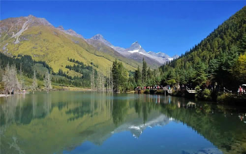
4. Dahaizi (Great Lake)
Dahaizi, known as "Cuoqian" in Tibetan, is the largest alpine lake in the Siguniang Mountain scenic area, located at an elevation of 3,800 meters. According to scientific research, the lake was formed after the retreat of the Quaternary glaciers. The area is lush with water plants and greenery, providing a serene environment that can purify the soul. The lake is home to alpine naked-scaled fish and serves as a migratory stop for birds such as the red-crested pochard and little egrets.


5. Huahaizi (Flower Lake)
Huahaizi, known as "Xiercang Meiduo Cuo" in Tibetan, is located at an elevation of 3,830 meters. It was originally an ice U-shaped valley, which later transformed into a marshy lake due to the accumulation of debris from the side valleys. In the summer, when flowers bloom and grasses flourish, the area resembles a jade green platter scattered with flowers and plants. Under the sunlight, it appears vibrant and colorful, shimmering with dazzling light.


6. Couple's Lakes
Adjacent to Huahaizi are two lakes known as the "Couple's Lakes," or "Quixi Cuo" in Tibetan. The lower lake, known as "Fuhai" (Husband's Lake), is rugged and powerful, while the upper lake, "Qihai" (Wife's Lake), is graceful and delicate. According to legend, after a hunter was poisoned by a curse, the eldest daughter accompanied him here to bathe in the pure lake water and heal his wounds.


7. Shibulong Hai
Shibulong Hai consists of two small lakes and can be accessed by hiking up the mountain trail opposite the cow shed at Dahai Zi. The trail first ascends a steep slope to reach a platform meadow. The elevation here is similar to that of the Second Peak's base camp, with the two locations separated by Dahai Zi, offering a distant view. Beyond the platform, the path continues up a rocky slope, and after crossing a pass at around 4,000 meters, you can reach Shibulong Hai.
From Shibulong Hai, the trail leads down to Dahuang Pengzi, located between Huahai Zi and Xiniu Hai. Every autumn, the route for the cross-country race follows the path from Xiniu Hai down to Dahuang Pengzi, then climbs over the Shibulong Hai pass to Dahai Zi. This challenging route tests the athletes' strength and endurance.


8. Bajiaopeng Hai
Bajiaopeng Hai is located on the mountain ridge to the right between Laoniu Yuanzi and Dahaizi, at an elevation of over 4,600 meters. The lake has a diamond-like shape and serves as the highest campsite for climbing Eagle Dove Peak. It is also an ideal spot to capture the reflection of Siguniang Mountain in the lake. From here, you can see the southern face of Yao Mei Peak. Camping under the starry sky at the lakeside, the atmosphere is exceptionally clear with countless stars and no wind, making the lake surface resemble a mirror. Due to its high elevation and steep terrain, this lake is rarely visited.
On clear days, Siguniang Mountain is within close view. The reflection of Yao Mei Peak in the lake is particularly spectacular when viewed from the shore. At sunset, the mountains glow golden, while at sunrise, the light scatters across the lake. At night, the starry sky and the Milky Way are fully visible, making this a must-visit destination for mountain photographers and outdoor enthusiasts.


9. Xiniu Hai
Xiniu Hai is the most famous lake at the end of Haizi Valley, located at an elevation of around 4,400 meters. The lake is oval-shaped and surrounded by stunning scenery. The water appears black due to the rocks and mud at the lake's bottom.
Xiniu Hai is surrounded by towering mountains, with a distant view of Yao Mei Peak, the main peak of Siguniang Mountain. On calm days, the reflection of Yao Mei Peak in the lake resembles a serene landscape, peaceful and majestic. The mountain ridge on the west side of the lake is also worth a visit, and it takes about 20 minutes to walk to the large cliff above Haizi Valley.


Vibrant, Delicious, Unforgettable: Chengdu Awaits Your Exploration!
Chengdu is calling!
Whether you’re savoring the fiery kick of Sichuan peppercorns or losing yourself in the serene beauty of the countryside, Chengdu offers an adventure for all senses. Our specially curated tours offer a mix of vibrant street life, tranquil gardens, and mouthwatering cuisine. No matter your interests, let us guide you through the city's most unforgettable experiences.
 7-Day Sichuan Tour Package from Singapore: Chengdu, Jiuzhaigou, Leshan & Emei
 2-Day Mt. Siguniang Trekking Adventure Tour
C. Selected Trekking Routes
a. Beginner-Friendly Routes
1. Shuangqiao Valley Stream Hike
· Route: Redwood Forest Parking Lot — Stream-side Plank Road — Redwood Forest Observation Deck — Return to Parking Lot
· Length: 2-3 kilometers (round trip)
· Altitude: 3800-4000 meters
· Difficulty: * (Flat and easy to walk, no steep slopes)
· Features: The entire route is a wooden plank road, flat and comfortable, suitable for family trips and tourists with weak physical strength. Along the way, you can admire alpine streams, redwood forests and distant snow-capped mountains, with fresh air and pleasant scenery. The tour takes about 1-2 hours, no professional equipment is needed, and comfortable sports shoes are sufficient.
2. Lama Temple to Dead Tree Beach
· Route: Changping Valley Entrance — Lama Temple — Shuidaba — Dead Tree Beach — Return
· Length: 5 kilometers (round trip)
· Altitude: 3100-3300 meters
· Difficulty: ** (Mainly flat roads and gentle slopes, good road conditions)
· Features: The most classic easy hiking route in Changping Valley. Along the way, you can experience the unique beauty of primeval forests, canyon streams and Dead Tree Beach, and also overlook the main peak of Mount Siguniang. The tour takes about 3-4 hours, suitable for first-time hikers. You can choose to hike round trip, or hike one way and ride a horse the other way (cost about 150 yuan/person).
3. Mount Siguniang Big Peak Climb
· Route: Siguniang Mountain Town — Guozhuang Ping — Dajian Bao — Jipengzi — Big Peak Base Camp — Big Peak Summit (5025 meters) — Return to Siguniang Mountain Town
· Length: Approximately 25 kilometers (round trip)
· Altitude: 3100-5025 meters
· Difficulty: ** (Gentle mountain terrain, clear route, no technical requirements)
· Features: As the lowest and least difficult peak to climb among the four peaks of Mount Siguniang, it is an ideal choice for beginners to start high-altitude snow-capped mountain climbing. After reaching the summit, you can overlook the magnificent scenery of the other three peaks up close, with a strong sense of accomplishment. Recommended 2-day itinerary: D1 Depart from Siguniang Mountain Town and hike for 6 hours to reach Big Peak Base Camp (equipment can be transported by muleteers); D2 Set off early in the morning to summit (3-4 hours to reach the peak), then return to the base camp and hike back to the town for 4-5 hours. No professional climbing equipment is needed, but warm clothes, non-slip hiking shoes and altitude sickness medication should be prepared.
b. Intermediate Routes
1. Changping Valley to Muluozi Camp
· Route: Changping Valley Entrance — Lama Temple — Dead Tree Beach — Muluozi Camp — Return
· Length: 20 kilometers (round trip)
· Altitude: 3100-3760 meters
· Difficulty: *** (Gentle altitude gain but long distance)
· Features: The core hiking route of Changping Valley. The scenery along the way gradually transitions from primeval forests to alpine meadows and snow-capped mountains. The terminal Muluozi Camp is one of the best places to admire Yaomei Peak. The tour takes about 6-8 hours, requiring a certain amount of physical strength and endurance. It is recommended to carry sufficient water and food (supplies in the scenic area are limited). You can choose to return on the same day or camp at Muluozi Camp for one night to experience the starry sky and sunrise.
2. Haizi Valley Flower Lake Hike
· Route: Haizi Valley Entrance — Chaoshan Ping — Flower Lake — Return
· Length: 8 kilometers (round trip)
· Altitude: 3100-3800 meters
· Difficulty: *** (Some sections are steep slopes and gravel roads, with rapid altitude gain)
· Features: The most popular hiking route in Haizi Valley. In summer, you can admire the beautiful combination of flower seas and lakes, and in autumn, you can feel the desolate beauty of primeval forests. The tour takes about 5-6 hours. It is necessary to wear non-slip hiking shoes and carry equipment such as trekking poles, sunscreen and sunglasses. It is recommended to travel in groups.
3. Mount Siguniang Second Peak Climb
· Route: Siguniang Mountain Town — Guozhuang Ping — Dajian Bao — Second Peak Base Camp — Second Peak Summit (5276 meters) — Return to Siguniang Mountain Town
· Length: Approximately 30 kilometers (round trip)
· Altitude: 3100-5276 meters
· Difficulty: *** (Slightly higher altitude, the summit section is somewhat challenging, requiring good physical strength)
· Features: With a steep peak shape, it offers a more immersive climbing experience than Big Peak, making it a perfect training ground for intermediate mountaineers. The summit section allows you to fully experience the charm of high-altitude climbing, and the view from the top is wide and the snow-capped mountain scenery is stunning.
· Recommended 2-day itinerary:
D1 Hike for 7 hours (16 kilometers in total) to reach Second Peak Base Camp;
D2 After summiting, return to the town, with a total hiking time of about 14 hours. It is recommended to carry basic equipment such as trekking poles, headlamps and warm sleeping bags, and make adequate physical reserves and altitude acclimatization in advance.
4. Mount Siguniang Third Peak Climb
· Route: Siguniang Mountain Town — Haizi Valley (Altitude Acclimatization) — Siguniang Mountain Town — Lama Temple — Third Peak Base Camp — Third Peak Summit (5355 meters) — Return to Siguniang Mountain Town
· Length: Approximately 44 kilometers (total distance)
· Altitude: 3100-5355 meters
· Difficulty: **** (Entry-level technical climbing, requiring basic equipment operation skills)
· Features: A technical peak famous for its steep rock walls and sharp peaks. The climbing process involves team climbing, rock climbing and other operations, which is a test of the climber's comprehensive ability. With its sharp and unique peak shape, it is highly recognizable among the four peaks of Mount Siguniang.
· Recommended 3-day itinerary:
D1 Hike 15 kilometers (6 hours) in Haizi Valley for altitude acclimatization;
D2 Hike 19 kilometers (7 hours) to reach Third Peak Base Camp;
D3 After summiting, return to the town, with a total hiking time of about 14 hours. A professional guide must be hired, and professional equipment such as climbing ropes, crampons and helmets should be carried. Suitable for enthusiasts with certain hiking experience and a desire to challenge technical climbing.
c. Challenging Routes
Changping Valley to Bibengou Crossing
· Route: Siguniang Mountain Town — Lama Temple — Dead Tree Beach — Muluozi Camp — Shuidaba — Kazigou Camp — Kazigou Tail — Pass (4641 meters) — Three Trees — Shanghaizi in Bibengou — Bibengou Scenic Area Exit
· Length: Approximately 35.7 kilometers (one way)
· Altitude: 3250-4641 meters
· Difficulty: ***** (High altitude, long distance, complex terrain; one of China's top ten classic crossing routes)
· Features: Known as the "Kiss of Siguniang", it spans two major scenic areas: Mount Siguniang and Bibengou. Along the way, it passes through various landforms such as snow-capped mountains, glaciers, meadows, forests and lakes, with extremely stunning scenery.
· Recommended 3-day itinerary:
D1 Siguniang Mountain Town to Muluozi Camp (14.5 kilometers, 5-6 hours, altitude 3250-3665 meters), accommodation at Muluozi Camp;
D2 Muluozi Camp to Kazigou Camp (10.5 kilometers, 4-5 hours, altitude 3665-3842 meters), accommodation at Kazigou Camp;
D3 Kazigou Camp to Shanghaizi in Bibengou (10.7 kilometers, 8-9 hours, altitude 3842-3558 meters), then proceed to Lixian County or Chengdu. Camping is required throughout the journey, and professional outdoor equipment (tent, sleeping bag, moisture-proof mat, alpine stove, etc.) should be carried. A guide and muleteer must be hired (cost about 500-800 yuan/day/person). It has extremely high requirements for physical strength, endurance and outdoor experience, suitable for senior hiking enthusiasts.
d. Hiking & Camping Tours (Recommended 3-day itinerary)
Day1: Changping Valley Deep Dive & Alpine Meadow Camping
· Route: Siguniang Mountain Town — Changping Valley — Dead Tree Beach — Muluozi Camp — Changping Valley Pasture Camp
· Length: Approximately 15 kilometers (one way)
· Altitude: 3100-3900 meters
· Features: First day, complete outdoor registration procedures at the Siguniang Mountain Scenic Area Administration, then hand over luggage to muleteers and hike with light packs under the leadership of a guide. On clear days, you can admire the graceful scenery of Yaomei Peak. The hiking on the day is relatively relaxed, and you can reach Muluozi Camp at the foot of Yaomei Peak around 2-3 pm. As an alpine pasture with beautiful scenery, it offers a stunning view of the steep and magnificent north wall of Yaomei Peak, and is also a traditional camping site for the Changping Valley crossing. On this trip, you will go deeper into Changping Valley and set up a camp at a suitable alpine pasture to immerse yourself in the natural surroundings.
Day2: Changping Valley Pasture Camp — Yangmantai Lake
· Route: Changping Valley Pasture Camp — Camel Peak Foot — Yangmantai Lake (Camping)
· Length: Approximately 8 kilometers (one way)
· Altitude: 3900-4700 meters
· Features: After breakfast, hike deep into Changping Valley, wandering through forests, streams and rugged peaks. Along the way, you can overlook Camel Peak at the bottom of the valley. After reaching the foot of Camel Peak, head to Yangmantai Lake—an alpine lake at 4700 meters above sea level, located at the glacier terminal of Yangmantai Peak and Camel Peak. It is an excellent spot to admire the reflections of Yaomei Peak's north wall, Daogou Peak and other mountains. Set up camp by the lake and wait for the stunning sunset and starry sky.
Day3: Yangmantai Lake — Siguniang Mountain Town
· Route: Yangmantai Lake — Changping Valley Pasture Camp — Dead Tree Beach — Changping Valley Entrance — Siguniang Mountain Town
· Length: Approximately 23 kilometers (round trip from the pasture camp)
· Altitude: 4700-3100 meters
· Features: The morning light is perfect for photography—don’t miss the chance to capture the panoramic view of the surrounding snow-capped mountains outside the tent. After breakfast, pack your personal belongings and prepare to exit the mountain by retracing the original route. The downhill hike is smooth, and you can revisit the beautiful scenery along the way, ending the immersive camping experience with unforgettable memories.
The Jiarong Tibetan Culture of Mount Siguniang
A. Introduction to Jiarong Tibetans
1. Historical Origin
The Jiarong Tibetans are an important branch of the Tibetan people, with a history dating back to the ancient Qiang people. Through long-term integration and development with surrounding ethnic groups, they have formed a unique cultural system. "Jiarong" means "residents in the river valleys", named after their generations of living in the river valleys of the western Sichuan Plateau.
2. Distribution Area
Mainly distributed in parts of Aba Tibetan and Qiang Autonomous Prefecture and Garzê Tibetan Autonomous Prefecture in Sichuan Province. Xiaojin County, where Mount Siguniang is located, is one of the core settlements of the Jiarong Tibetans. Tibetan villages such as Changping Village and Shuangqiao Village have preserved the most authentic Jiarong culture.
3. Cultural Characteristics
Jiarong Tibetan culture integrates the dual attributes of plateau nomadic culture and river valley agricultural culture. It not only retains the core elements of traditional Tibetan culture but also incorporates regional characteristics, forming distinct recognition in architecture, costumes, diet, folk customs and other aspects.


C. Architectural Culture
1. Traditional Residences
· Architectural Style: Represented by "watchtower-style Tibetan houses", mostly stone-wood structures. The walls are built with local natural stone, and the roof is flat or gabled, covered with stone slabs or tiles, which have windproof, cold-resistant and earthquake-resistant functions.
· Spatial Layout: Most houses have three floors. The first floor is used for raising livestock and storing farm tools; the second floor is the living area, including a living room, bedrooms and a kitchen, with a hearth in the center of the living room (used for heating, cooking and worship); the third floor is a scripture hall (for enshrining Buddha statues and scriptures) and a storage room, reflecting the living concept of "separating humans and animals, and prioritizing religion".
· Decorative Features: Door and window frames are carved with exquisite patterns, mostly eight auspicious symbols, flowers, birds and religious symbols; indoor walls are painted with murals in bright colors, depicting Buddhist stories and natural landscapes; prayer flags are hung on the roof to pray for blessings and ward off evil spirits.
2. Watchtower Architecture
· Functional Orientation: A landmark building of the Jiarong Tibetans, with multiple functions such as defense, observation and storage. Historically, it was used to resist foreign invasions, and now it has become an important symbol of cultural heritage.
· Structural Characteristics: Mostly square or octagonal, with heights ranging from ten to tens of meters. The walls are thick, with shooting holes and observation windows; built with pure stone without adhesives, they are extremely solid. Some watchtowers have survived hundreds of years of wind and rain and remain intact.
· Representative Buildings: A large number of ancient watchtowers are still preserved in Changping Village and Zhonglu Tibetan Village around Mount Siguniang, scattered with Tibetan houses, forming a unique plateau village landscape.


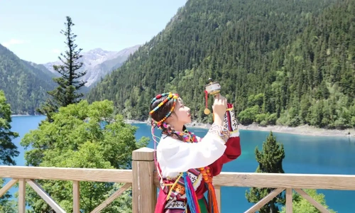
D. Costume Culture
1. Men's Costumes
The upper garment is mostly a black or dark blue Tibetan robe ("Chuba") with wide cuffs for easy labor; a colorful belt is tied around the waist, hanging accessories such as waist knives and flints, which are both practical and decorative; the lower garment is long pants, paired with Tibetan leather boots or cloth shoes; a felt hat or fur hat is worn to resist the cold wind on the plateau.


2. Women's Costumes
The upper garment is a short Tibetan robe or front-opening shirt in bright colors (red, green, blue, pink, etc.), with exquisite embroidery on the neckline, cuffs and placket; the lower garment is a pleated skirt with a wide hem, which is elegant and flexible when walking; multiple belts are tied around the waist, wearing silver necklaces, earrings, bracelets, rings and other accessories, some inlaid with corals, agates and turquoise, showing luxury; a embroidered headscarf or "fox fur hat" is worn, with hair braided into multiple small braids adorned with hair ornaments.


3. Cultural Connotation
The colors, patterns and accessories of Jiarong Tibetan costumes have specific meanings. Red symbolizes auspiciousness and celebration, blue represents the sky, and green implies grasslands; patterns are mostly derived from natural things (flowers, plants, birds and beasts) and religious symbols, reflecting reverence for nature and yearning for a better life; the production techniques of costumes (embroidery, weaving, silverware making) are skills passed down from generation to generation by Jiarong women, carrying the collective memory of the nation.


E. Diet Culture
1. Characteristic Cuisine
· Butter Tea: A daily drink of the Jiarong Tibetans, brewed from butter, strong tea and salt. High in calories, it can resist the cold on the plateau, aid digestion, and is an essential drink for receiving guests.
· Tsampa: One of the staple foods. Highland barley is roasted and ground into powder, mixed with butter tea or plain tea to form balls for consumption. Easy to carry, it is suitable for nomadic and hiking life.
· Yak Meat: A specialty of the plateau, with firm texture and rich nutrition. It can be made into hand-grasped meat, yak meat hot pot, air-dried yak meat, etc., with a delicious taste, and is a delicacy for festivals and receiving guests.
· Yangyu Ciba (Potato Glutinous Rice Cakes): Made from local potatoes, steamed and mashed into mud to form cakes. They can be boiled or stir-fried, served with seasonings such as chili and Sichuan pepper, with a soft, glutinous and spicy taste.
· Highland Barley Wine: A traditional fine wine fermented from highland barley. With a low alcohol content and mellow taste, it is an essential drink for festivals, weddings and other occasions, symbolizing reunion and happiness.
2. Dietary Customs
When dining, the principle of "respect for elders and juniors" is followed, with elders eating first; when receiving guests, the host will first offer butter tea and highland barley wine, then present tsampa and hand-grasped meat to express hospitality.
Diet is closely related to the plateau environment, mostly high-calorie and easy-to-store foods, adapting to the high-altitude and low-temperature climate characteristics; ingredients are mostly local, such as highland barley, potatoes, yak meat and mutton, reflecting the survival wisdom of "living off the land".


F. Religious Beliefs
1. Core Beliefs
The Jiarong Tibetans mainly believe in the Gelugpa sect (Yellow Sect) of Tibetan Buddhism, while retaining some customs of primitive Bon religion, forming a belief pattern of "coexistence of Buddhism and Bon".
2. Religious Sites
· Lama Temples: The most famous around Mount Siguniang is the Changping Valley Lama Temple, founded in the Qing Dynasty. As a Gelugpa temple, it enshrines Buddha statues such as Sakyamuni and Tsongkhapa, with exquisite murals and sculptures, and is an important place for Jiarong Tibetans to carry out religious activities.
· Shrines and Mani Piles:Every Tibetan house has a family scripture hall and shrine, enshrining Buddha statues, scriptures and butter lamps; mani piles (stacked stones carved with scriptures) and prayer flags (colorful cloth strips printed with scriptures) can be seen everywhere outdoors. Believers pray by turning prayer wheels, reciting scriptures, hanging prayer flags, etc.


3. Religious Practices
Daily religious activities include reciting scriptures in the morning and evening, lighting butter lamps, and turning prayer wheels; on important religious festivals (such as Tibetan New Year, Shoton Festival, Wangguo Festival), large-scale scripture recitation ceremonies, Buddha exhibition, mountain circumambulation and other activities are held. Believers dress in costumes and go to temples to worship, praying for peace, health and a bumper harvest.
G. Folk Customs & Festivals
1. Traditional Festivals
· Tibetan New Year: The most grand festival, held on the first day of the first lunar month in the Tibetan calendar. Before the festival, every household cleans the house, makes butter flowers and brews highland barley wine; during the festival, people wear new clothes, have a reunion dinner, exchange hadas and dance Guozhuang, lasting 3-7 days, filled with a joyful and peaceful atmosphere.


· Wangguo Festival: Harvest festival, held in August of the Tibetan calendar to celebrate the highland barley harvest. Villagers dress in costumes, hold highland barley ears, and parade around farmland and villages to pray for a bumper harvest in the coming year; at the same time, horse racing, archery, singing, dancing and other activities are held, with a lively scene.


· Flower Appreciation Festival: Held in spring (April-May), when alpine rhododendrons are in full bloom. Villagers go to grasslands and valleys to appreciate flowers and worship mountain gods. Young men and women find partners through antiphonal singing and dancing, inheriting love culture.


2. Folk Activities
· Guozhuang Dance: The most representative folk dance of the Jiarong Tibetans. Men, women, old and young form a circle and dance to the rhythm of sheepskin drums and lusheng flutes. The dance steps are neat and powerful, and the lyrics mostly praise nature, love and a better life. It is an essential activity for festivals, weddings and other occasions.


· Horse Racing Festival: Common in festivals such as Wangguo Festival. Riders wear traditional costumes and gallop on the grassland, competing for speed and skills, showing the boldness and courage of the Jiarong Tibetans; at the same time, there are competitive events such as archery and wrestling, attracting villagers and tourists from surrounding areas to watch.


· Wedding Customs: Jiarong Tibetan wedding ceremonies are grand and complex, including proposal, engagement, wedding procession and wedding banquet. During the wedding procession, the groom's team rides horses and plays suona to the bride's house, where the bride's family sets up a "door-blocking wine" to test the groom; at the wedding banquet, everyone dances Guozhuang and sings drinking songs to bless the newlyweds with happiness.


· Mountain-Worshipping Festival: A highly religious Jiarong Tibetan ritual held on the 4th day of the 5th lunar month. On the day, the mountain-worshipping platform is adorned with fluttering prayer flags, and Tibetans in costumes gather with highland barley wine, yak meat and roasted buns to worship. Hundreds of lamas, led by a senior lama, meditate and recite scriptures, then parade around the platform with conches, gongs and drums, followed by Tibetans scattering "Longda" (paper prayers) to pray for peace and harvests. Afterward, the senior lama blesses pilgrims, and joyful Guozhuang dances, horse racing and wrestling fill the site with joy. The core "Weisang" ritual involves a living Buddha leading lamas to carry straw men/horses, scatter "Longda", play instruments and burn the straw figures on the ridge, with Tibetans singing and a horse team of young Tibetans galloping past to show bravery.


H. Traditional Handicrafts
1. Thangka Painting
An important part of Tibetan Buddhist art, themed on religious stories, Buddha statues and natural landscapes. Painted with natural mineral pigments (gold, silver, coral, turquoise, etc.), it has bright colors and a long preservation time. Jiarong Thangka emphasizes detailed depiction, smooth lines and a unique style, and is a work of art with great collection value.


2. Tibetan Incense Making
Made from unique natural raw materials in Tibet such as cypress wood, sandalwood, clove and saffron, through multiple processes including crushing, mixing, kneading, shaping and drying. With a mellow fragrance, it has the effects of praying for blessings, repelling insects and purifying the air. Tibetan incense making is a traditional craft of the Jiarong Tibetans, mostly passed down in families, and hand-making experiences are available in some Tibetan villages.


3. Embroidery
Widely used in clothing, headscarves, wallets and other items. Using silk thread as raw material, it embroiders patterns such as flowers, plants, birds, beasts and religious symbols, with harmonious color matching and delicate stitching. Jiarong embroidery emphasizes the combination of realism and freehand brushwork, reflecting love for nature and life, and is an essential skill for women.


4. Silverware Making
Made of pure silver through processes such as melting, forging, carving and inlaying, into necklaces, earrings, bracelets, rings and other accessories. The patterns are mostly eight auspicious symbols, dragons and phoenixes, lotus flowers, etc., with exquisite shapes and auspicious meanings. Silverware is not only a decoration but also a symbol of wealth and status.


Chengdu in a New Light: Curated Itineraries Tailored Just for You!
Step into Chengdu’s vibrant pulse and uncover its rich history, culture, and cuisine.
Whether you’re trekking through the lush forests of Mount Qingcheng, exploring ancient monuments, or diving into the sizzling hotpot culture, our expertly crafted tours offer a full immersion into Chengdu’s essence. From cultural explorations to foodie adventures, you’ll see this dynamic city like never before.
 4 Days Classic Siguniangshan Mountain Hiking Tour with Wolong Panda Base
 3 Days Mt.Siguniangshan Leisure Tour with Top Highlights
What to Do in Siguniang Mountain
A. Visiting Museums and Exhibition
1. Geological Museum
The Geological Museum is located in the main hall of the Siguniang Mountain Visitor Center. Construction of the Visitor Center began in early 2008, and it was put into use at the end of 2009. This year, it underwent a comprehensive upgrade and is now completely renovated. The overall architectural structure incorporates Tibetan architectural features and covers an area of 2,998 square meters. The Geological Museum occupies 472 square meters and is divided into three main exhibition areas: geological evolution, biodiversity, and Jiarong culture. It is a comprehensive museum that integrates park geology and landforms, plant and animal resources, and human history.


Museum Ticket Price: Free of charge
Opening Hours: 08:00 AM - 06:00 PM
Location: Changping Valley Visitor Center
Highlights:
· Geological Formation Exhibits: The museum presents detailed displays about the geological history of the Siguniang area, including the formation of the Qionglai Mountain Range and the Siguniang Peaks. Visitors can learn about the ancient tectonic processes and forces that caused the rise of these majestic mountains and the creation of stunning geological features like glaciers, valleys, and rock formations.
· Rock and Mineral Samples: The museum houses a collection of rock and mineral samples from the Siguniang area, allowing visitors to examine firsthand the variety of geological materials that make up the mountain. This includes samples of granite, shale, and sedimentary rocks, which provide insight into the region's complex geological structure.
· Glacial and Erosion Studies: The museum also focuses on the study of glaciers and erosion, with models and explanations about how glaciers shaped the landscape, carving valleys and creating unique rock formations. It highlights the importance of glaciers in the mountain’s ecology and how climate change may impact these fragile systems.
· Interactive Learning: The museum includes interactive displays and models to engage visitors, offering a deeper understanding of the processes that have shaped the region’s dramatic topography.
2. Natural Museum
The Siguniang Mountain Nature Reserve Science Education Base covers an area of 6,000 square meters, with a building area of 3,200 square meters. It consists of two main sections: the science education museum and tourism service facilities, including dining and shopping areas. The science education museum, which was completed in October 2019 and opened to the public, focuses on providing information about the reserve’s basic facts, rare plant and animal species, geological history, and local customs. The museum’s exterior walls are constructed using traditional Jiarong Tibetan building techniques, featuring slate and stone blocks to form the walls, which are referred to as "stacking stones to build a room" in the Book of the Later Han Dynasty.


Museum Ticket Price: Free of charge
Opening Hours: 08:00 AM - 06:00 PM
Location: Shuangqiao Valley Service Center
Highlights:
· Flora and Fauna Exhibits: The museum features informative displays about the various plant species found in the Siguniang Mountain range, from alpine meadows to dense forests. There are also sections dedicated to the region’s wildlife, including the snow leopard, giant panda, and golden monkey, highlighting their habitats, behaviors, and conservation efforts.
· Ecological Zones: Visitors can learn about the different ecological zones of Siguniang, ranging from the lowland forests to the high-altitude meadows and glaciers. The museum provides a clear picture of how the diverse altitude and climate variations create distinct ecosystems in this mountainous region.
· Conservation Awareness: The museum also emphasizes the importance of conservation, with displays that educate visitors about local efforts to preserve the fragile ecosystems and protect endangered species that live in the area.
3. Tibetan Cultural Exhibition
The Siguniang Mountain Outdoor Museum, located at the Changping Valley Visitor Center, covers 438 square meters indoors and 600 square meters outdoors. Completed in June 2021, the museum focuses on the theme "Human and Mountain," highlighting the cultural stories of the Jiarong Tibetan people and their connection to Siguniang Mountain. It showcases the region's outdoor resources, mountain culture, and the history of outdoor activities. The museum’s architecture blends traditional Tibetan styles with modern design, offering interactive exhibits using display panels, electronic screens, and physical artifacts. The museum provides an immersive experience that celebrates the unique cultural and outdoor heritage of Siguniang Mountain.


· Museum Admission: Free (Public Service)
· Opening Hours: 08:00 AM - 06:00 PM
· Location: Changping Valley Visitor Center
B. Photography
Siguniang Mountain is a photographer's paradise, offering a wide range of subjects: from snow-covered peaks to alpine lakes, and dense forests to Tibetan villages. Here are some tips to help you capture the stunning landscapes of Siguniang:
1. Golden Hours: The best time for landscape photography is during the golden hours—the period just after sunrise and just before sunset. During this time, the light is softer, creating dramatic shadows and highlighting the mountain's textures.
2. Use a Wide-Angle Lens: To capture the grandeur of the mountain ranges, valleys, and lakes, a wide-angle lens is essential. It allows you to capture expansive landscapes in one shot and gives a sense of depth to your photos.
3. Focus on the Details: While the sweeping views are stunning, don’t forget to focus on the small details—like wildflowers, streams, and the unique architecture of Tibetan villages. These details will add variety to your photo collection.
4. Tripod for Long Exposure: For capturing the motion of waterfalls or flowing rivers, a tripod will help stabilize your camera for long exposure shots, which create a beautiful silky effect on moving water.
5. Bring Extra Batteries: Cold temperatures at higher altitudes can drain your camera batteries quickly, so be sure to bring extra batteries and memory cards.
6. Respect Nature: Be mindful of your surroundings and follow Leave No Trace principles. Avoid disturbing wildlife or damaging fragile ecosystems while taking photos.
C. Other Outdoor activities
1. Ice Climbing
Ice climbing originated from mountaineering and is a sport that involves using specialized climbing equipment to scale ice walls, often referred to as "ballet on ice waterfalls." Siguniang Mountain is blessed with abundant ice wall resources, making it one of the most popular ice climbing destinations in China. It offers a variety of climbing routes with different difficulty levels, suitable for climbers of all abilities.
In Shuangqiao Valley of the Siguniang Mountain scenic area, the mountain streams that flow in the summer freeze into over a hundred ice waterfalls and ice walls during the winter. On both sides of the valley, hundreds of natural ice waterfalls hang, with over 30 of them accessible for beginners, while the rest are mid-to-high difficulty ice walls. Siguniang is the only destination in China with such a large number of ice walls of varying difficulty levels, and its convenient access makes it a prime location for ice climbing. Every ice season, ice climbing enthusiasts from both China and abroad come to learn, train, and experience the sport.


Equipment to Prepare:
· Main rope, helmet, harness, mountaineering boots, crampons, ice axes, ice screws, main carabiner, belay device, webbing, auxiliary rope, ice hooks, etc.
· Sunglasses, hat, jacket and pants (windproof and waterproof), sunscreen, water bottle, etc.
Ice Climbing Guide Services:
The guide services are provided by coaches from the Ling Climbing School. Each guide leads 1-2 climbers, selects suitable routes, and conducts multiple ascents. During the climbs, the guide will teach not only the techniques but also share climbing experience, providing climbers with a rich and immersive climbing experience.
Important Notes:
· Before ice climbing, inspect the terrain, assess the ice quality, and choose the appropriate climbing route and timing.
· Warmer temperatures or windy weather are unfavorable for ice climbing.
· Ensure all safety measures are in place, including wearing a harness, helmet, waterproof and warm gloves, and securing safety ropes before climbing.
· Be cautious of falling ice.
· When inserting the ice axe into the ice, do not apply excessive force and avoid swinging the axe, as this could cause the ice to crack and compromise its stability.
· When kicking ice, pivot around your knee joint and kick the ice smoothly with your foot to avoid injury to the other leg.
2. Rafting
Siguniang Mountain whitewater rafting is located in the Shuangqiao Valley scenic area. The entire rafting course is about 4.5 kilometers long. The river here is relatively gentle compared to more thrilling rafting spots like Hongkou and Jiulong Gorge around Chengdu. However, the water comes from melting snowmelt, making it refreshingly cool. Sitting in the raft and quietly enjoying the beautiful scenery of Shuangqiao Valley, you can skip a section of the strenuous trekking. While rafting, you'll also have the opportunity to see the snow-capped peaks, the unique blue sky and white clouds of the plateau, alpine meadows on both sides of the river, and sandthorn forests, all of which make for a scenic and relaxing experience.


Important Notes:
· Before boarding, make sure to wear your life jacket properly and keep your valuables safe.
· During the rafting trip, standing up in the raft is strictly prohibited, as is horseplay or fooling around.
· Children must be supervised by a parent or guardian during the rafting experience. They are not allowed to play with paddles or splash water.
· Do not bring cash or valuables onto the raft. If you need to carry a camera, make sure to wrap it in a plastic bag beforehand.
· While rafting, avoid excessive movement. Hold onto the safety rope, keep your feet tight, and lean your body toward the center of the raft.
· Always follow the instructions and commands given by the staff.
3. Outdoor Camping
The stunning natural scenery of Siguniang Mountain offers an ideal setting for outdoor camping. The scenic area is divided into three valleys: Shuangqiao Valley for sightseeing, Changping Valley for eco-tourism, and Haizi Valley for specialized outdoor activities. Camping is not allowed in Shuangqiao Valley, so camping is limited to Changping Valley and Haizi Valley. Camping provides an excellent way to get close to Siguniang Mountain, allowing you to truly experience the intimate connection between humans and nature.
· Camping Options in Changping Valley
There are many camping spots in Changping Valley, with the most popular being Lower Gan Haizi, Upper Gan Haizi, Mulaizi, Turtle Rock, Yangmantai Heiba, and Chazi Gou Heiba. Among them, the best campsite for an overnight stay is Mulaizi. Located 20 kilometers from the valley entrance, it lies behind the Yao Mei Peak of Siguniang Mountain. It takes about 4 hours on foot or horseback from Lama Temple to reach the site. Mulaizi offers a spacious meadow, surrounded by snow-capped peaks and streams. There are nearby service points, such as a protection station and cattle pens, offering hot water and heating.
· Camping Options in Haizi Valley
Haizi Valley has several camping spots, including Guozhuangping, Zhaijieping, Chaoshanping, Laoniuyuanzi, Dahuizi, and Huahaizi. Guozhuangping, Zhaijieping, and Chaoshanping are the best locations for photographing the Siguniang Mountain starry skies and sunrise/sunset on the Golden Mountain. The wind tends to be strong at night, but the campsites are only 1-2 hours' walk from the valley entrance. Laoniuyuanzi is a well-established campsite for Japanese climbers, as its surrounding area has a large water flow drop, which makes it suitable for powering campsites. Dahuizi and Huahaizi, located 4-5 hours from the valley entrance, offer stunning mountain and water views. Both locations have nearby cattle pens where local herders provide food, hot water, and heating services.


2. Communication & Network
· Mobile Signal: Major scenic areas (Shuangqiao Valley, Changping Valley) have coverage from China Mobile and China Unicom. However, remote areas of Haizi Valley or high-altitude mountain ridges may have no signal. It’s recommended to carry a spare phone with a different operator’s SIM card.
· Internet: WiFi is available in hotels, restaurants, and scenic area visitor centers in Rilong Town. Network stability is poor in mountainous areas, so download offline maps (such as Gaode Maps or Baidu Maps) and essential travel information in advance.
Travel Tips
1. Best Travel Time
· Spring (April-May): Alpine rhododendrons bloom, meadows turn green, and the temperature is pleasant, suitable for hiking and flower viewing.
· Summer (June-August): Cool climate, an ideal summer resort with lush meadows and clear lakes. However, there is more rainfall, so rain gear is necessary.
· Autumn (September-October): Clear sky and fresh air, forests display colors such as red, yellow, and green, making it the golden season for photography and hiking.
· Winter (November-March next year): Covered in snow, suitable for skiing and snow viewing. However, some roads may be closed, so safety should be prioritized.
2. Transportation Guide
· Public Transportation: Buses from Chengdu Chadianzi Bus Station to Xiaojin County run daily, with a stop at Rilong Town (Siguniang National Park entrance), taking about 4.5 hours. You can also take a bus from Chengdu to Danba, which stops at Rilong Town.
· Self-Driving: Depart from Chengdu, via Dujiangyan, Wolong, and Balangshan Tunnel to Rilong Town, totaling about 200 kilometers with good road conditions. However, the Balangshan section has a high altitude and may have snow in winter, so anti-skid chains are recommended.
· In-Scenic Transportation: Sightseeing buses are available in Shuangqiao Valley (80 yuan/person). In Changping Valley, you can choose sightseeing buses (20 yuan/person, to Lama Temple) or horse riding. No sightseeing buses are available in Haizi Valley, so hiking or horse riding is required.
3. Accommodation Recommendations
· Sgura Manor Hotel
As the core project of Sgura Wenlv City, Sgura Manor Wooden House Hotel is located at the north end of Sgura Wenlv City, 220 kilometers away from Chengdu and 100 meters away from the tourist center of Siguniang Mountain changping valley Scenic Area. The wooden house is surrounded by Changping Village. Sgura Wenlv City is a comprehensive tourism service project piloted by Siguniang Mountain Scenic Area.


Address: No.4 jinzi street, siguniang mountain town, Xiaojin, Sichuan, China
Phone: +86-837-2787999 | +86-19508100778
· La Maison
The La Maison provides a great place for travelers to relax after a busy day. The La Maison is an ideal choice for travelers who want to take in the sights and sounds of Xiaojin. With multiple attractions nearby including Haizi Valley Scenic Area, Changping Valley and Changpingcun, guests will find plenty to keep themselves occupied. When guests have some time on their hands they can make use of the onsite facilities. According to our guests, the location of this hotel is one of the best around.


Address: No. 009, Village Group 1, Changping Village, Siguniangshan Town, Xiaojin, Sichuan, China
Phone: +86-17381703154
· Yueshan Holiday Hotel
The Yueshan Holiday Hotel provides a great place for travelers to relax after a busy day. Visitors to Xiaojin will find that the Yueshan Holiday Hotel is a fantastic accommodation choice. The nearby area boasts an abundance of attractions including Changpingcun, Cat's Nose Ridge and Rilong Town. At the end of a busy day, travelers can unwind and relax in the hotel or go out and enjoy the city. This Xiaojin hotel features parking on site.


Address: Beside Provincial Highway 303, Rilong Town, Xiaojin, Sichuan, China
Phone: +86-837-8813333
4. Altitude Sickness Prevention & Response
· Prevention Measures: Take anti-altitude sickness drugs (such as rhodiola) 1-2 weeks in advance; avoid strenuous exercise and rest for 1-2 days to acclimatize after arrival; drink plenty of water, eat more fruits and vegetables, and avoid drinking alcohol and overeating; keep warm to prevent colds.
· Response Methods: If mild altitude sickness symptoms such as headache, dizziness, or shortness of breath occur, rest and oxygen inhalation (available at some hotels and inns in the scenic area) can relieve them. If symptoms are severe (such as vomiting or difficulty breathing), descend the mountain immediately and seek medical attention.
5. Food Recommendations
· Tibetan Copper Pot Hot Pot
A signature dish with a rich yak bone broth base. Layered with fresh yak meat, Tibetan pork, wild mushrooms, and local vegetables, it’s simmered in a traditional copper pot for a mellow, savory flavor. Perfect for warming up on cold plateau nights.


· Yak Meat Soup Pot
Simpler than the copper pot version, the clear broth is boiled for hours with yak bones. Thinly sliced fresh yak meat is blanched briefly, offering a tender, juicy texture that’s not gamey.


· Cordyceps Stewed Duck
A nourishing dish combining cordyceps and local duck. Simmered slowly, it’s believed to replenish energy and strengthen the body, ideal for adapting to high altitudes.


· Old Preserved Pork Stir-Fried Fungus
A signature dish with a rich yak bone broth base. Layered with fresh yak meat, Tibetan pork, wild mushrooms, and local vegetables, it’s simmered in a traditional copper pot for a mellow, savory flavor. Perfect for warming up on cold plateau nights.


6. Equipment Suggestions
· Clothing: Bring warm clothes (such as waterproof jackets, down jackets, fleece jackets) regardless of the season, as the weather in high-altitude areas is changeable with large temperature differences between morning and evening. Bring sun protection clothing and long pants in summer, and thick sweaters and snow boots in winter.
· Hiking Equipment: Non-slip and waterproof hiking shoes, trekking poles, backpacks, sun hats, sunglasses, sunscreen (SPF50+), moisturizer, and lip balm (anti-chapping).
· Other Items: ID card, bank card, cash (no signal in some remote areas), power bank, rain gear, common medicines (cold medicine, gastrointestinal medicine, painkillers, band-aids), camera, and memory cards.
7. Cultural Etiquette
· Respect Tibetan Customs: Take off your hat when entering Tibetan villages or temples; do not touch Buddha statues, murals, or prayer flags at will; do not step on mani piles or take photos of Tibetan compatriots without permission (ask for consent first); do not waste food or make noise during meals.
· Eco-Friendly Travel: Do not litter and take waste out of the scenic area; do not damage vegetation or wildlife habitats; abide by scenic area regulations and do not enter undeveloped areas without permission.
Nearby Attractions
1. Bibengou Scenic Area
Approximately 100 kilometers from Siguniang National Park, with a 2.5-hour drive. Famous for snow-capped mountains, glaciers, waterfalls, and colorful forests, it is the endpoint of the "Changping Valley-Bibengou Crossing" and can be combined with Siguniang National Park for a connected trip.
2. Danba Tibetan Villages
About 80 kilometers from Siguniang National Park, with a 2-hour drive. Featuring unique blockhouses and Tibetan village architecture, among which Jiaju Tibetan Village and Zhonglu Tibetan Village are popular attractions, allowing visitors to feel the strong Jiarong Tibetan culture.
3. Wolong Giant Panda Nature Reserve
Approximately 60 kilometers from Siguniang National Park, with a 1.5-hour drive. It is an ideal place to watch giant pandas and get close to the national treasures.
Mount Siguniang is a destination that shines in every season—whether you’re chasing the spring flowers, escaping the summer heat, admiring the autumn foliage, or embracing the winter snow, it offers unique and unforgettable experiences. By understanding the siguniang mountain weather, choosing the best season for your needs, and following practical travel tips, you can fully immerse yourself in its natural beauty and cultural charm. Respect the local culture and protect the ecological environment, so that this "Oriental Alps" can continue to captivate travelers for generations to come. We wish you a wonderful journey filled with stunning views and precious memories in Mount Siguniang!
Your Way Holiday’s Handpicked Guide to Siguniang National Park and the Best Adventures on Mount Siguniang
We design private and tailor-made Chengdu tours customized to your travel style at affordable local prices. You’ll enjoy the comfort of a private, spacious car and the company of a professional local guide with over 5 years of experience, dedicated exclusively to you or your group. From transportation and tickets to authentic dining experiences (we always recommend the dishes most loved by locals), everything will be arranged according to your preferences. Please take a look at some of our most popular Chengdu tours below:
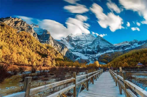 4 Days Daocheng Yading Hiking Tour from Chengdu by Flight
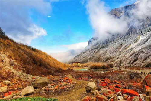 5 Days Sichuan Trips with Hailuogou Glacier Exploration
Not exactly what you’re looking for? Don’t worry — all of our Chengdu tours can be fully customized based on your interests, schedule, and budget. We specialize in creating unique Chengdu experiences that go beyond the guidebook, giving you the chance to truly connect with the local culture and people. Our enthusiastic tour experts are always ready to provide detailed suggestions and will respond to your inquiry within 24 hours. Ready to explore Chengdu your way? Contact us today and let us design a Chengdu shopping experience that fits your style. Your Way Holiday looks forward to your message! We're ready to design an unforgettable Chengdu trip for you anytime.
Wechat: Chinaprivatetour
24 Hours Hotline:
+8613735411378
Certificate of Excellence
2012~2026

Your Way Holiday
(Your Privacy is Protected)
1 to 1 tailor-made service from our professional travel advisors for the most sophisticated
Constantly excellent reviews for attraction, hotel and service Competitive price
Local experts provide quality tours Best selected knowledgeable local guides Authentic local restaurants
7*24 hours available to create you a worry-free tour. No Hidden Fees and absolutely no pressure to buy. Secured


Hello, I am planning to travel to Mount Siguniang in August. Can you provide a private transport from a hotel in Chengdu to accomodation near Mount Siguniang? Could you also advise the cost of this service? Thanks for your help.
Replied:17 April 2026
Thank you for your inquiry about private transport to Mount Siguniang.
We can provide private one-way transfer service from your hotel in Chengdu to your accommodation near Mount Siguniang. The journey takes approximately 4–5 hours, depending on road conditions, and our experienced drivers are familiar with the route.
For a detailed cost quote, we will need to know your exact travel date, the number of passengers, and the type of vehicle required (e.g., sedan or SUV). August is a popular travel season, so prices may vary slightly based on availability.
Please contact us at [email protected] with your specific details, and we will send you a customized quotation.
Your Way Holiday - Your trusted partner for private tours in China!